On Wednesday afternoon, I wanted to exploit my all too rare access to the coast to go for a swim in the surf. I'm still a wimp in the cold though, so had packed a wetsuit for protection. After a shower and some warming broth I headed down to North Curly - although there were a few boardriders in the surf, it was reasonably deserted and the sea was a bit flukey. I reluctantly made a sensible (not-a-local) decision and headed over to Dee Why where I hoped there were more people about. Sick of driving, and seeing the sun sink further on the horizon, I didn't venture beyond the carpark at the south end of the beach and eventually got into the water in the ocean baths. This was the site of our Year 7 swimming carnival, and I was amazed when I was in the water how shallow it was, with my hands scraping the bottom in places. Despite the (lack of) depth I still froze, and found myself increasingly mis-navigating over the length and breadth of the pool as my cognitive function declined and I turned into a zombie. I don't know how IceBergs do it.
Thursday, I dropped Bob at the TA office and on a whim, drove to the green patch under Roseville Bridge. I had looked in the street directory and there seemed to be the option of following trails from the parkland up through the park to Mona Vale road. Paid my park day use fee, sussed out what to wear, and headed off past a gang of workmen who were doing a lot of chainsawing. The significance of this didn't strike me until I returned.
The track was initially broad and a firm, sandy surface alongside the end reaches of the harbour. It continued around the cove like this, passing huge expanses of exposed mollusc's on the tidal fringes. The path narrowed although stuck to the edge of the watercourse, and then climbed up to an elevated area still running parallel to the now narrowed tidal creek. This was real bush single-track, and quite a bit of fun. I had to watch my footing, however the variations in surface led me to think that it was a good form of training in so much that it got the muscles used to moving over differing surfaces and adapt quickly. (Taking a cue from what Graeme the Super Physio explained to me about my bung ankle).
A broad rock shelf terminated this section of the run and I made my way across the mossy surface (a little too brazenly on reflection) and then back onto a new track which ran under a low rock shelf. Luckily my growth was stunted when I was eleven, so I didn't have to stoop too much! The trail wound its way through bush which was quite different to that around Canberra; areas thick with banksias and gumnut men, lush wet forests (water? what's that?), and flowing creeks. There was little bush bashing to the termination of this track ("Carroll Creek") where a metal bridge crossed the creek with a rusty pipeline running alongside it, and according to my scan of the marked and named trails marked on the street directory, this would join up with the "Governor Phillip" track and thence to Mona Vale Rd. I searched one set of depressions in the undergrowth after another hoping that it was the start of a slightly overgrown trail that would soon reveal itself. All were littered with large branches and overgrowth, and, with much reluctance and a long time spent bush bashing and not running, I admitted defeat (on this occasion) and backtracked over the bridge. Stairs led ahead, and although certain that this just led into the borders of the suburban Forestville, followed in case I had missed something and to get moving once more.
A broad disused bitumen road led up, although it did not make for easy running, as whole trees with thick branches blocked the road at regular intervals. At first I thought that this was to prevent vehicular access, 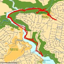 however realised that they had been blown down. I ended up on a signposted access area, complete with National Parks office and access to where I could have parked for free. I decided to continue to run up the road which was very quiet and turn around at the end. After the stop-start nature of the run during the last km or so I felt that I was flying! I called into the National Parks Office (open 8:30am to 5:00pm Monday to Friday) to ask about the access across the creek and maybe pick up a map. Despite cars in the carport, the door was locked with a sign to come back between 8:30 and 5:00 (it was around 11:00) and nobody answering my knocks. Reluctantly I backtracked, diverting via a sign marked to the Casuarina track. This was good, easy running for a while along a ridge-line, which then dropped down to a wet, overhang where one walked underneath a curtain of dribbling water. Across the other side, the track was good once more, however here a large clump of downed trees proved too much to waste more time on attempting to climb over, and I backtracked and retraced my steps to where I started.
 however realised that they had been blown down. I ended up on a signposted access area, complete with National Parks office and access to where I could have parked for free. I decided to continue to run up the road which was very quiet and turn around at the end. After the stop-start nature of the run during the last km or so I felt that I was flying! I called into the National Parks Office (open 8:30am to 5:00pm Monday to Friday) to ask about the access across the creek and maybe pick up a map. Despite cars in the carport, the door was locked with a sign to come back between 8:30 and 5:00 (it was around 11:00) and nobody answering my knocks. Reluctantly I backtracked, diverting via a sign marked to the Casuarina track. This was good, easy running for a while along a ridge-line, which then dropped down to a wet, overhang where one walked underneath a curtain of dribbling water. Across the other side, the track was good once more, however here a large clump of downed trees proved too much to waste more time on attempting to climb over, and I backtracked and retraced my steps to where I started.
With the benefit of having gone over the route, I was certainly faster on the return, and once again captivated by many aspects of it. On nearing the car I saw that the chainsaw gang were still busying themselves on many large fallen trees, including one which had decimated a large shed on the side of the road. Having run far too little distance, far too slow, I continued past the car and did a 'quick' lap around the roadway under the bridge to the eastern roundabout where boats are launched and back again. Another 2kms which a much more sprightly pace of under 4:30. All up, around 14kms in about 97 minutes, with many, many stops. I could have run on a road, or travelled to somewhere I knew, but I love the thrill of exploration.
0 Responses to “Roseville Bridge exploration”
Leave a Reply