Trial Cycle of the Bush Capital 25km course
Published Thursday, July 28 by Carolyne | E-mail this post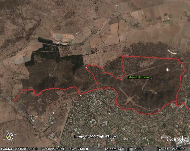
I rode around most of the Bush Capital 25km run course this afternoon, which encompasses the 16km route and is the start and finish of the Marathon and Ultra courses. I was unsure of the exact start, however crossed the basketball court to a very narrow metal bridge with a rail on only one side. If we do use this, be very careful of the drop at the end, especially when tired at the end of the run.
After entering the nature park through a narrow access point in the fenceline adjacent to Ainslie Village, the path of compacted red soil climbs gradually to meet the main path around the base of Mt Ainslie. The surface is a good and fine grained, with only gradual undulations as it leads to the crossing at the road up Mt Ainslie. Entering the nature park next to the 'National Pistol Club', the path is narrow, although hard packed and soon terminates at another management trail with a good surface. On the map above, this is on the top right hand corner, where the red line turns to the left. This undulates a little more, however I missed the turnoff which should lead us on Saturday around the back of Campbell Park Offices. These stand out like a white concrete town incongruously amongst the trees on one side, and the airport on the other.
The path winds gently up and down here, although at the end of the straight section marked above, it turns east and climbs fairly sharply for a short distance. ACT Vets who have run the Mt Ainslie monthly handicap course will know this as the climb near the end of the run. At the crest however, instead of following it down to the finish, it turns sharply and steeply once more to the start of what is probably the most challenging part of the course. The track here is less 'groomed', with grass closely cropped by kangaroos only broken by a brief width of hard compacted trail, frequently littered with jagged rocks. It climbs fairly steadily, with some spectacular views across the city available to the south east.
Following a fenceline for some distance, the track gives way to some sections of very rocky and unstable ground with a sharp pitch. One warning: It is possible that riding the bike actually made this section feel worse than it would be to run, however I think it would be prudent to exercise some caution here, especially if a little uncertain of your footing. Eventually the conical roof of a water tank appears, and rounding this leads to a gentle downhill on a sealed section of road, which gives way to another broad light coloured trail with billabongs on the northern side. This is marked on the map by the red line on the left joining the return track on parallel to the base of the map.

This track leads to another access point into Mt Majura Nature Park and signs and a large stile indicate this. At this point, the 16km course returns to the High School by turning left to follow the trail adjacent to the rear of houses in Hackett. For those doing the longer options, the trail winds behind more houses to the right, before it begins to climb once more when it turns away from the homes when running around the back of another, smaller, flat roofed water tank. I carried the bike across an equestrian gate, and the track climbs into thicker bush here, with Mt Majura looming above. If you care to look for kangaroos here you may see the macro fauna of this district. Whilst the 'roos in the Mt Ainslie section are of fairly normal proportions, those I saw here today are either a direct link to the prehistoric giant marsupials, or were small horses masquerading with pouches and powerful tails. Aki beware!
The track to the Federal Highway is straightforward - it twists and turns, however without climbing over stiles (like one does in the Triple Tri) it is just a matter of following it to the end. There are a few reasonable dips and crests here which we shall no doubt notice on the way back, especially those doing the longer options. Once again there are some stunning views across the Bush Capital here if you care to look, it always reinforces how lucky we are to live in a city like this.
On rejoining the loop where the 16km runners turned off, the trail is generally easy running (very easy from the seat of the bike), following the rear of houses to the end of Antill St, where one must cross the old access road to the tip and squeeze through the access points on either side. The final few kilometres are fairly undemanding . . . the surface is good, navigation is easy, and the course is rolling at best.
"R" and "N", ran the 16km a few weeks ago, if they had taken your course description and map with them, they would have been on a nature tour/stroll.
They will enjoy it Saturday.
"OAO"
Thanks for that FD - looking forward to it, just hope my body is too!
great description - almost makes me think i should give it a go but you won't catch me running mountains (unless it's for orienteering of course)...plus i'd have to miss golf and that just wouldn't do ;-)
Sounds like a good challenge