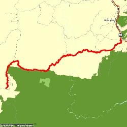
The Six Foot Track - The Slower Version
Published Monday, November 28 by Carolyne | E-mail this postALMOST THE LAST DRAFT
The date of the long awaited Six Foot Track - The Slower Version! had arrived, and an anticipatory group of excited Cool Runners descended on an unsuspecting Katoomba on Friday night for a pasta meal and recognisance of the next days activities.
Lucky Legs, Peter the PRB, Wombatface, Wildthing and the ‘worth-his-weight-in-chocolate’ Mr Wildthing and I met for dinner at The Hatters Cafe a few doors up from our quirky, but entirely adequate, accommodation at the Town Centre Motel. Late 50’s red brick motel rooms provided plenty of opportunity for Lucky Legs and I to giggle like schoolgirls sharing their first dorm room for most of our time together, whilst the Wildthings were in the penthouse garret in the adjoining 1930’s St Elmo Guesthouse.
A buffet breakfast was included, and with the ‘Heritage’ Dining room opening at 7:30am, we were first in to ensure that we could get to the Explorer’s Tree meeting place for the 8:00am start. I was resolute in sticking to FortiJuice for the day or two pre-run, however others tucked in to a ‘Big Breakfast’ of sausages, eggs, bacon and toast. I made the unfortunate error of drinking the very bad instant coffee, which was particularly foul – not recommended and not to be repeated!
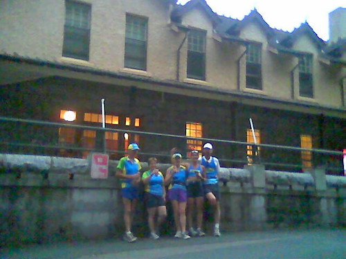
We piled into the ideal transport of Mr Wildthings’ Pajero and drove to the Explorers Tree in steady drizzle. My main concern was getting too cold during the day if the rain continued, and I hadn’t finally decided what to wear. At the designated meeting point were Horrie and Belinda and Chonky. After introductions or re-introductions all around, we posed for a group photo next to the tree, huddled close together as the rain fell down from the trees overhead in huge globs.
 Reluctant to carry too much, I settled on keeping on a Cool Running Tri Top over a singlet, with a R4YL cap to keep the worst of the rain off my face. At around 20 minutes past eight we started in the wet and slippery conditions, jointly surprised at how quickly the wider section of track gave way to a series of steps descending into Nellie's Glen. This was incredibly beautiful, although slow going. While Chonky ran off ahead to get to the river and back for a ‘quick’ run, our group of six stayed together for safety. This was an experience not a race!
The descent into Nellie's Glen was spectacular through the deep gorge with the rock walls rising vertically on either side. With the rain continuing it was sometimes difficult to tell where the creek ran, and what was run-off from the rain on our course. Good track markings of a Red Hiker and arrows led the way at intervals to ensure that we went along the correct water course!
 The path widened, and Horrie and I were delighted to finally be able to stretch our legs, and jogged along comfortably, climbing through a gate on the first barrier, and then finding green metal stiles at all the others. In one stretch, the sound of birdsong was deafening, with Bell-birds and Whip birds dominating the raucous. It was good to move along, and the track moved through varying countryside, still wet from the deluge before emerging at the dark stripe of bitumen to mark the roadway at Megalong Valley where Rob Wildthing was waiting for us, camera in hand.
Here we shed rain-jackets (Yay!) and Wildthing (Sob) as the sky had cleared and we were eternally optimistic. Another group photo shivering together at the Megalong Valley sign as we gazed off to the mist rising from the mountains and we were off, through the fence and past the historic cemetery. A 4WD with car trailer came along and past us soon as we were moving, indicative of the grazing land that we were to encounter over the next few kilometres.
A wide firetrail style track was marked by PRIVATE PROPERTY - NO TRESPASSING signs on either side, easily ensuring that we wouldn't make a mistake diverting up the driveways to the farm-lets in the Valley. I began to feel cold with the light breeze on my sodden Tri Top, so unzipped this to my waist leaving only a relatively dry CR running singlet next to my skin. Cattle grazed all around, which meant that as we regrouped for a photo op at the cattle grid which marked the start of our trek along a single track surrounded by the vivid purple haze of Paterson's Curse we were all covered in a fine black film of flies. Supported by the cowpats which we were soon to become vigilant in avoiding, the number of flies was enormous and very annoying.
A track led up through the spring growth of still-green grass over a hillock and alongside a ridge-line. Eventually leading to a forested area of narrow single track through bushland. Mysteriously, a cow or cows had preceded us, and we were alerted to the occasional huge globs of dung along the narrow path, one with a large footprint (?Chonky's) in the middle. Nearing the river, as we had just traversed a gully, Chonky came bounding along in the other direction and we stopped and chatted briefly before he continued on his speedy way.
He had advised us that a small party of young hikers were ahead, and sure enough, as we rounded the bend to the dramatic sight of Bowtell's Suspension Bridge. Built in 1992 by an army outfit, it is named after the first soldier of the unit to have been killed in Vietnam. A couple of young guys in camouflage fatigues were snacking at it's base. Peter announced that he was going to cross, and as tempting as this was (the sign indicating that it was strictly for one person at a time), I decided that we didn't have time for too much play, with another 30kms+ ahead of us. When I told Belinda and Wombatface what Peter was doing though when I caught up to them on the track, each turned back to try it as well.
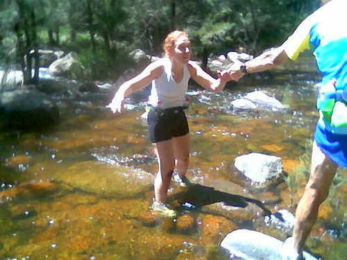
I was only seconds behind Horrie when I got to the designated crossing point at the Cox's River, about 1.5km along from the bridge. A good opportunity for an excursion into the bushes, and I then sought to find which of the trails led to to the best way across. With the river level somewhat higher than is usual in March, this was not obvious. I did some scouting before starting to cross, then heard the call of the ChickyBabe as she made it down to the river. I backtracked, and we crossed together, hopeful that the Polar footpods would continue to work at the other side. (They did). Horrie settled on a log, squeezing out his socks and refueling, whilst LL sought the water tank adjacent to the camping site.
 After a long delay, the group of 3 bridge walkers came through and crossed the river. Five Trail bike riders were having a break here as well, and after we studied the maps, topped up water and posed for the obligatory photograph with my low resolution phone (sorry for the quality!), we were on our way to start the traditionally hardest part of the track. Horrie and Belinda came along for a short distance to 'just see' what the hills were like before turning back. We were now a rag tag gang of four, bright is CR colours of Yellow, Blue and Green.
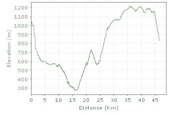 This point marked the climb up Mini Mini, and wound its way through the bush from the 15.5km mark (from the river crossing at the lowest elevation, right) to a saddle with a dramatic, large, overfed Red Bellied Black Snake on a wall adjacent to the track. I was alerted to the fact that we had mobile coverage here on receiving a text from Aki and attempted to call the Widthings to let them know where we were. Rob let us know that he was at Pluviometre, and with the hills continuing to rise, it seemed a long way away.
We had committed one of the first crimes of distance running 101, and underestimated our water needs for this leg. The verges of the tracks were dotted with the tall straight trunks of majestic eucalpyts, and the ground littered with a colourful carpet of native flowers in a spectrum of mauve, purple, violet and yolk-yellows. I started to collect these at one point, putting sprigs in the band of my now-empty fuel belt. Despite only picking one, invariably small bloom of each type, my waist was soon laden with dancing flowers.
Around this point, our favourite ChickyBabe was beginning to wane and kept entreating me to go on ahead as she rested a little. With the long lean legs of Peter and Wombatface striding off in the distance I insisted that the first law of bush-trekking was never to leave someone alone. When sitting on a pretty stone 'bench', fatigue and the big breakfast came to haunt her, and concerned about dehydration, I headed off to find the Wildthings, an estimated 3 kilometres away with Peter when he and Wombatface had returned to view. We walked, rather than jogged this section, and I was fascinated to note that we were doing a comfortable 13-14:00 minute pace walking easily, whereas my usual insistence on 'running' (a loose term) often had me at well over 15 and even 18 minute pace.
On a bend we came across a couple of hikers, weighed down with backpacks and camping gear, stopping to munch a apple. We bid them farewell, and continued, rounding yet another bend to see 'something' in front of us; I discounted it being the Pajero, rationalising that it was a rusted structure or Workman's donga instead. Wildthing's CR Tri Top drying on a log meant that we were in no doubt that we had come across our wonderful support crew. It turned out that we were only 1.9 km away, so before too long, Wombatface and Lucky Legs came striding up as well to rest, rehydrate and recuperate in our designated lunch stop.
I changed into blissfully clean dry socks, and left my Tri Top and singlet on a sign to dry out a little in the emerging sun. Although not especially hungry, I used the opportunity to have a FortiJuice, Fruit Squeezy and risked a Special K bar for something solid. I had had two Gu's along the trail before this. I drank plenty of water though, and ensured that my fuel belt bottles were full. Wombatface made himself a couple of tomato sandwiches, Lucky Legs was introduced to the low GI wonders of creamed rice, and Peter had a couple of bread rolls with cheese. I Stripped down to a crop top, we were off once again, this time with Wildthing jogging with us. My Forerunner indicated that I had stopped for over 56 minutes at Pluviometre.
There was another 220m climb to reach the highest point, but this was spread over the luxury of around 8 kilometres. We all jogged and walked in a companionable fashion, with Rob Wildthing leapfrogging ahead every few kilometres, allowing us to refill water bottles and for some to munch salty potato crisps. Wombatface, the resident expert having completed the last two six foot track runs kept reassuring us that the last significant hill was over, and once we turned the next left bend . . . .
We crossed a number of creeks and welcomed the cool water on our hot feet. After Alun Creek, we came across a gully full of ferns which was a vibrant luminous lime green in the late afternoon light. Tree Ferns stood sentinel overlooking the thick coverage of ferns covering the ground across the gully and up the banks of the trail. It was rather surreal . . . .
We noticed the stand of pine trees and a sign looking as though it indicated a forestry coop, and could hear the sound of what seemed like traffic in the distance. Not too far along the trail with the pine plantation on the right hand side, we saw a solo runner travelling light, carrying only a water bidon. Then, at crossroads was the welcome sight of the Pajero and and the wildthings chatting to a bearded guy called Alan. After introductions all around, we found that he was camping at the nearby campsite here at the Deviation, and was here hiking with a few mates from Canberra.
 Checking the map for distances, our gang of four headed off again, meeting the Pajero at the roadway to Jenolan Caves, and agreeing to 'pick up' Wildthing further down the track where it veered off running parallel to the road and we had around 4 kilometres to go. The track in this intermediate section was a surprising mix of steps and tight single track, relatively slow going as we now neared our destination. Where the track widened to open, spindly forest, everybody was able to move along pretty well.
After around 3 or 4 kilometres the trail came to a clearing where it veered away from running parallel to the roadway. Here we met the Pajero, Wildthing joined us, and we were all exultant with the prospect of finishing soon. Close to the start of the diversion, a sign on the left hand side of the trail indicated that there were 4 kms to go. A wide undulating trail led to a clearing where there was a toilet block and an open field with the Jenolan Cabins backing on to it. Through a fence, and the quality and width of the track changed, followed later by the thickness of the vegetation. Cracks of dramatic thunder broke through the late afternoon silence, sometimes developing into an extended rumbling which never seemed to end. I wondered if Town Hall Station was nearby and the world's longest train was about to arrive.
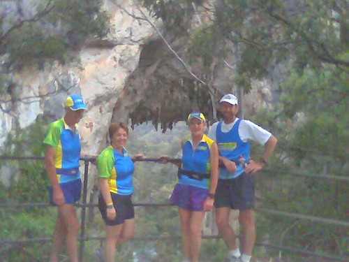 It apparently became fairly fairly loose and shaley along here, with a few steep descents, however I was too busy chatting to the wonderful Wildthing to notice! At some point the track changed to a sealed tourist path which wound it's way down to Caves House. A mixture of sloping narrow track and occasional steps, the track afforded some spectacular views over the valley and to the lake. We had to stop at Carlotta's Arch for yet another group photo, where we could see the lake framed by the dramatic limestone.
Over the final few hundred metres we probably slowed down in reverence of the gravity of what we, the Lucky Legs six foot track assault, had achieved. Dusk was descending in the valley, and a few flashes of lightening lit the sky which was already a luminous azure. All our senses were overwhelmed, the creak of crickets no match for the wall of honeysuckle to our right. We (mostly!) joined hands as we walked the final steps down to the roadway at Caves House where Rob and his camera met us.
To 'do it properly', we jogged down to the correct finish point and celebrated. The odd couple came out of Caves House for a postprandial stroll, and we rejoiced in every strange look. Our group at the finish were wearing matching Blue and Yellow tops and caps, under-dressed for the cooling conditions, and smiles as wide as the Mammonth Cave ahead of us.
~~~~~~~~~~~~~~~~~~~~~~~~~~~~~~~~~~~~~~~~~~~~~~~~~~~~~~~~~~~~~~~~~~~
I'm enjoying reading this Carolyne! Keep the detail going. It'll be a great record of the weekend. When you took that photo, the uphill *had* finished! [so had the left-hand corners]
Sounds like an amazing experience. I'm looking forward to the next episode!
Fantastic report/instalment about what apparently was a wonderful trek.
Great report Flashduck. Sounds like an unbelievable day. Congratulations to all of you.
GG
Keep writing,FD! I just keep on coming back for more & more detail, some of which I'd forgotten .....like the flies & cow dung!! Fabulous writing about an unbelievably fabulous day!
FD....this is wonderful to read & re-read your detailed account of our great experience! Both Ewen & I have put ours up on the main message board....make sure you do the same! I just keep on coming back for more!
Loved reading your report FD. If I could only have half of your tenacity.
Hope your recovery is going well. :)
All the best
Gronk
Thanks to Lucky Legs, I have finally been able to leave a message Carolyne. A wonderful report of a fabulous day. Very well written once again. I hope we can get up there again in January for the next instalment. Catch up with you soon.